Saturday, February 12, 2011

How Smoking Birthed America

Tobacco Plantation

After my exhausting adventure with Celeron, I headed back into my time machine to visit the British.  The year was 1747, two years before Celeron left to try to get the Ohio Indians in line with the French.

The French suspected that all the English conspired to make claims on the Ohio Land.  They were partly right. The colonists in Pennsylvania were mostly just interested in trade with the Indians.  They had no desire to obtain more land. However, the Virginians were a different matter.

To understand Virginia’s economy in 1747, think of gambling in modern Las Vegas. Just as gambling IS the economy in modern Las Vegas, tobacco farming was the economy of Virginia. 

The problem with tobacco farming was that it tended to exhaust the soil.  And it was difficult to maintain the status quo after the plantation owner would die. For example, if the plantation owner should have 5 sons, would he break the plantation up into five smaller farms as part of the inheritance?   And what would happen to those five lots once his grandsons became of age?  You can only break a plantation down so far until it is not economically viable.

Obviously, the only solution was growth – meaning more land.  So where to go? To the east of Virginia was the Atlantic Ocean. And the ocean is not exactly a great place for a tobacco farm. Who wants wet cigarettes? North and south were other colonies. So that left one direction – West. And west was the Ohio country.

Of course, Indians were in that land.  But that was not a huge issue.  It was known that Indians would usually be happy to sell their land for some guns, liquor and trinkets.  Yes, they may regret the sale later, but that was too bad. All sales are final was the motto.

The French also claimed that area. That was a bit more risky.  For pissing off the French in America could start a war between England and France in Europe.  

But while the French claimed that land, in reality there were no French men living there permanently - just a few fur traders and missionaries.  You can claim anything you want, but it is another matter to defend that claim.

Another interesting fact (unnoticed at the time) was that the British living in Virginia started to think of themselves as more Virginians than British.  By 1747 many had been born in America (such as George Washington) and had never visited the mother country.  So while they were not anti-British, they started to slowly think of themselves as separate.  This foreshadowed what would happen in 30 years.  So the fact that moving into the Ohio territory might cause diplomatic problems for London was not a great concern to the Virginians.

So on 1747 The Ohio Company was formed. More on the Ohio Company in the next post.

Sunday, August 29, 2010

1749 - Indian Troubles Down the Ohio River


We left the Forks of the Ohio (future home of Pittsburgh) and followed the Ohio River west. Our first stop with the French village called Logstown. Two years prior, the French had built 30 or so log cabins (hence the name Logstown) at this site to act as a trade village with the local Indians.


Shawnee Indians Claimed They Owned Ohio Country

When we arrived in 1749 the local Shawnee Indians claimed that they owned the Ohio Country and they would continue to trade with the English. This pissed Céloron off and after a heated argument we got back down our canoes and headed west down the Ohio River.


The Mighty Ohio River

We continue the long journey down the Ohio River until we arrived at the Indian village of Pickawillany. Pickawillany was located about 70 miles north of modern Cincinnati on the Miami River.


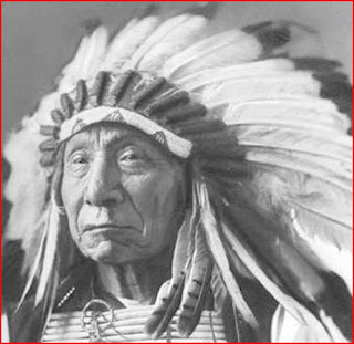
In Pickawillany we met an old Miami Chief who was called “Old Briton.” Old Briton received this nickname due to the fact that he seemed to favor trading with the British. It was Celerons goal to re-establish exclusive trade with the Miami Indians.

Miami Chief "Old Briton"


The negotiations went poorly. Old Briton claimed he was tired of being screwed by price gouging from the French. He claimed the British offered much better deals.


Celeron got red in the face and screamed that Old Briton would face “dire consequences” if he did not stop trading with the English. At this point Celeron turned to us and said, “Fuck this, we are going home back to Montreal”.

Saturday, August 28, 2010

1749 - Claiming The Forks of the Ohio for France

After resting at Chautauqua Lake we carried our canoes a bit further to the Allegheny River. The Allegheny River was a welcome sight as we were finally able to again ride in our canoes instead of carrying them. And as a further bonus, at this point we were actually travelling with the flow of the river. Going with the current, FTW!


We floated down the Allegheny River


The Allegheny River in the 21st century


We took the Allegheny River down to where it meets the Ohio River. At the point in which the Allegheny River, Monongahela River and Ohio meet is referred to as The Forks of the Ohio. Eventually this would become the site of the city of Pittsburgh. But in 1749, there was just a simple Indian trading post.


In 1749 there was only an Indian trading post at this site


At The Forks of the Ohio we met some British fur traders. Seeing these traders pissed off Céloron. Céloron told them in no uncertain terms that they need to get the fuck out of French territory. It was a tense situation, but the British traders decided that discretion was the better part of valor after seeing 200 armed French marines with Céloron.

The Forks of the Ohio in the 21st Century


Even at this time (1749) it was obvious that controlling the The Forks of the Ohio was of key strategic importance. As roads did not yet exist in the wilderness of Ohio Country, rivers were the primary means of transportation. So whoever controlled the Forks pretty much would be able to control the Indian trade.


Céloron placed a sign (a lead plate) that claimed this area for France. In a sense this was no different than a dog pissing to mark his territory.


Lead Plate Claiming Territory for France
(it looked better new)

Monday, August 23, 2010

1749 - Up a Creek and Building a Road

The Céloron's expedition finally reached Lake Erie and we travelled along the southern shore in our canoes. We were looking for Chautauqua Creek. Chautauqua Creek drains into Lake Erie. It is connected to Chautauqua Lake which feeds into the major rivers such as the Allegheny River and the Ohio River.

Chautauqua Creek is based in western New York just east of modern day Erie, Pennsylvania.

See that purple dot? We had to build a road and carry our canoes to that dot.
That Sucked.


Note about the importance of Rivers in 1749

In 1749 Ohio Country there were no roads, trails, highways, reliable maps or GPS. Basically, the only way to travel without getting hopelessly lost was to follow rivers. As such, the rivers and the Great Lakes acted as the modern interstate freeways of today.


Chautauqua Creek

If you look at Chautauqua Creek you can see it is too dinky for canoes to travel up it. As such we had to build a primitive road (on an old Indian trail) from Lake Erie to Chautauqua Lake. Part of this old road still survives in the 21st century. (It was weird to see the road in 2005 and then travel back in time to help build this road).


A Modern Day sign showing where we built that road all those years ago.

Finally we arrived at Chautauqua Lake! We relaxed at the lake for a few weeks as we were all exhausted from building that stupid road.


Morning breaks at Chautauqua Lake


We did some fishing and caught plenty of Muskellunge fish. I snuck this camera from the 21st century and took a picture of the lake during morning.


Dinner at Chautauqua Lake

Sunday, August 22, 2010

1749 - Paddling up the Niagara River


After a long journey along the north shores of Lake Ontario, we (the Céloron's expedition) are now headed south on the Niagara River to Lake Erie. The Niagara River is unusual in that it flows from the south to the north. It sucks that we always seem to be paddling against the river.

Half way up the river, we ran into the Niagara Falls. While the Falls are quite beautiful, we obviously could not paddle our canoes up the Falls. So we had to carry these HEAVY canoes around the Falls. While exploration may seem exciting looking back from the 21st century, in reality it is just exhausting work. The history books never mention being constantly wet, tired and being bit by mosquitoes.


Had to carry our canoes around this. Ugh.

1749 - Reached Lake Ontario!

After a long (and wet) journey up the St Lawrence River, we (the Céloron's expedition) have finally reached Lake Ontario. Met some indians along the way, but otherwise it is just wilderness.

Modern Map of Lake Onario. We plan to travel along the north shore.


Shore of Lake Ontario

June 15, 1749 - Starting our canoe trip with PJ Céloron!

The Trip Starts!

Well, today is the start of the big adventure! I have successfully been able to join the expedition led by Pierre Joseph Céloron de Blainville. (“PJ” to all us guys).

While it is somewhat scary knowing I will soon be going into the wilderness, I will not be alone. This expedition consists of 213 French Marines. As a time traveler from the 21st century, I did not realize how tough men were during this era. I have no doubt we can handle any problems from the Indians (or savages are they are called).

We are starting our journey near what is the modern city of Montreal. Of course, during this period of time the city is quite small. And they don’t even have a hockey team!

We will be taking 23 canoes up (west) the St Lawrence River headed to Lake Ontario. I imagine I will be wet most of this trip.


St Lawrence River near Montreal


Our mission is to talk to the various Indian tribes and tell them to stop trading with the British. This land belongs to France, not Britain.